Now in load testing · Next beta round September 30, 2026
RoadWatch
Know what is ahead before you get there.
Free real-time road surface conditions reported by chasers, for chasers.
Sign up to help us test.
Our next testing round begins September 30, 2026
Get Early access to features.
Testing Progress
Where the beta stands today, and what comes next.
First testing round complete
May 2026We ran our first closed test in May with a subset of our original volunteer testers. A huge thank you to everyone who got out in the field and sent in reports. Your data and feedback shaped everything that follows.
Load testing and hardening
In progressDuring load testing we ran into performance issues under heavy concurrent use. Rather than push ahead, we are taking the time to fix them properly, hardening the backend and tightening the app so the next round holds up when a lot of chasers are reporting at once.
Next testing round
September 30, 2026This fall we will roll out an improved build to a wider group of testers. If you signed up above, watch your inbox for a TestFlight invite as we get closer. We appreciate your patience while we make RoadWatch ready for the field.
The Problem
Paved roads that suddenly turn to gravel or dirt without warning. Standard navigation apps do not alert you to surface changes.
Road conditions change constantly. That gravel road from last season might be paved now, or it might be washed out entirely. Most maps are months or years out of date.
Google Maps and Apple Maps show you where roads are located, but they do not show you what those roads are made of or their current condition.
How It Works
Report Conditions
Submit reports for dirt, gravel, construction, floods, or washouts. Quick one-handed use while stopped.
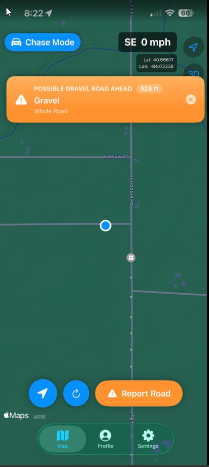
Proximity Alerts
Audio and visual alerts before you reach a reported condition. Stay focused on the road.
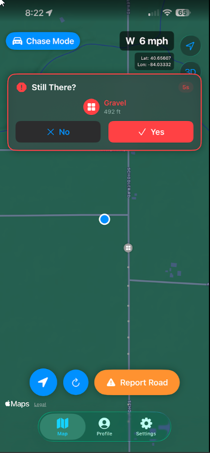
Still There?
Reports decay over time unless confirmed. The map always reflects current conditions.
Chase Mode
Simplified interface for active field use. Voice alerts and large touch targets.
Demo
Screenshots
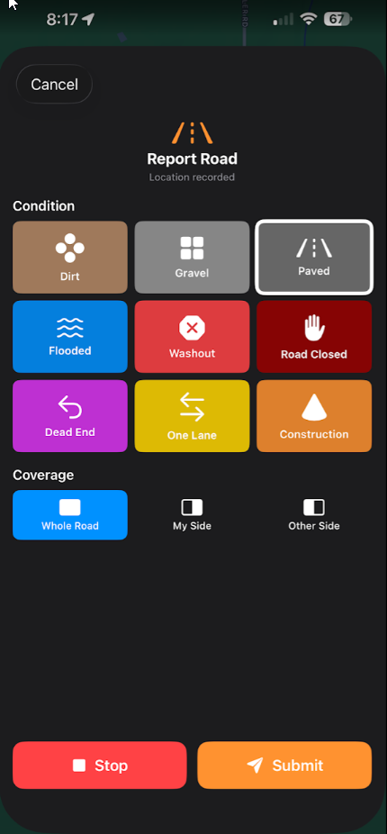
Quick one-handed reporting
Chase Mode with alerts
Still There? confirmations
Why We Built This
RoadWatch began as an idea during one of our storm chases. While chasing in Nebraska, we were at chase speed and suddenly a paved road became gravel, then dirt shortly after that. This was not the first time we encountered this issue. This can become more than inconvenient in heavy rains and low visibility.
Standard mapping applications show road locations but not surface types or current conditions. We built what we think will help us all. The app gives warnings if that is all you want, or lets you actively mark surface types or temporary obstacles such as a road closure, washout, or dead end.
With this data, others receive alerts before reaching those conditions. No subscriptions, no fees. A free resource to help the community stay safe.
App Details
iOS
Available via TestFlight
Free
No subscriptions or fees
Sept 2026
Next beta round